| Class |
Description |
Code/ID |
|
| |
Coordinates
(Polar_x,Polar_y)
(Grid_x,Grid_y) |
Polar stereographic and grid coordinates. The grid
coordinates refer to grid cells in the OSISAF NH product grid and
can be used to reassemble the gridded ice chart. The polar
stereographic coordinates are not used in this edition of the data.
|
|
|
| |
| Area_id |
Sea ice, source onknown |
900 |
|
| Sea ice, source Radarsat |
901 |
|
| Sea ice, source NOAA |
902 |
|
| Sea ice, source DMSP |
903 |
|
| Estimated sea ice, source unknown |
800 |
|
| Estimated sea ice, source Radarsat |
801 |
|
| Estimated sea ice, source NOAA |
802 |
|
| Estimated sea ice, source DMSP |
803 |
|
| Open water (sea) |
200 |
|
| Cloud |
400 |
|
| Land |
300 |
|
| NO-DATA |
500 |
|
| |
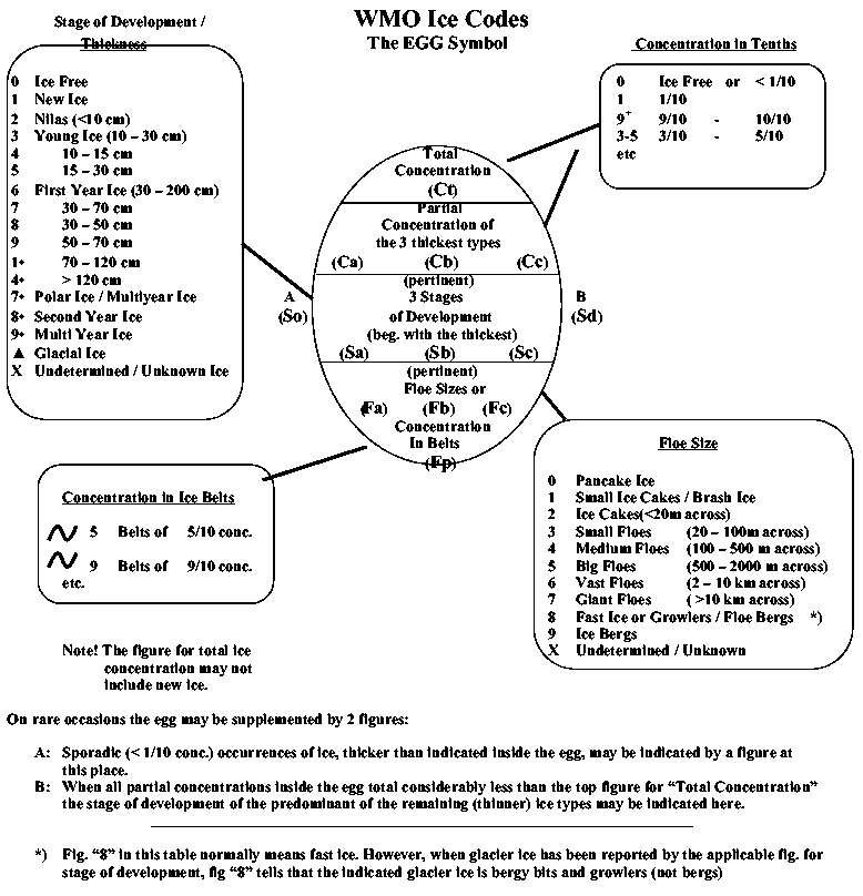
Ice Concentration
(Ct, Ca, Cb, Cc) |
Definition |
WMO code |
SIGRID code |
| Ice Free |
0 |
00 |
| Less than 1/10 (open water) |
< 1 |
01 |
| Bergy Water |
D |
02 |
| 1/10 |
1 |
10 |
| 2/10 |
2 |
20 |
| 3/10 |
3 |
30 |
| 4/10 |
4 |
40 |
| 5/10 |
5 |
50 |
| 6/10 |
6 |
60 |
| 7/10 |
7 |
70 |
| 8/10 |
8 |
80 |
| 9/10 |
9 |
90 |
| More than 9/10 less than 10/10 |
9+ |
91 |
| 10/10 |
10 |
92 |
Concentration Intervals
Cl: Lowest concentration in interval
Ch: Highest concentration in interval |
|
ClCh |
| 1/10 - 3/10 |
1-3 |
13 |
| 4/10 - 6/10 |
4-6 |
46 |
| 7/10 - 9/10 |
7-9 |
79 |
| 9/10 - 10/10 |
9+ |
91 |
| Unknown |
X |
99 |
| |
Ice Types (Thickness/
Stage of Development)
(Sa, Sb, Sc, Sd, So) |
Definition |
WMO code |
SIGRID code |
| Ice Free |
0 |
00 |
| No Stage of Development |
|
80 |
| New Ice |
1 |
81 |
| Nilas, Ice Rind (< 10 cm) |
2 |
82 |
| Young Ice (10-30 cm) |
3 |
83 |
| Grey Ice (10-15 cm) |
4 |
84 |
| Grey-White Ice (15-30 cm) |
5 |
85 |
| First Year Ice (30-200 cm) |
6 |
86 |
| Thin First Year Ice (30-70 cm) |
7 |
87 |
| Thin First Year Ice Stage 1 (30-50 cm) |
8 |
88 |
| Thin First Year Ice Stage 2 (50-70 cm) |
9 |
89 |
| SPARE |
|
90 |
| Medium First Year Ice (70-120 cm) |
1• |
91 |
| SPARE |
|
92 |
| Thick First Year Ice (>120 cm) |
4• |
93 |
| SPARE |
|
94 |
| Old Ice |
7• |
95 |
| Second Year Ice |
8• |
96 |
| Multi Year Ice |
9• |
97 |
| Glacier Ice |
Δ |
98 |
| Undertermined/Unknown |
|
99 |
| |
Floe Size
(Fa, Fb, Fc, Fp, Fs) |
Definition |
WMO code |
SIGRID code |
| Pancake Ice (30 cm - 3 m) |
0 |
00 |
| Shuga/Small Ice Cake, Brash Ice (<2 m) |
1 |
01 |
| Ice Cake (<20 m) |
2 |
02 |
| Small Floe (20-100 m) |
3 |
03 |
| Medium Floe (100-500 m) |
4 |
04 |
| Big Floe (500-2000 m) |
5 |
05 |
| Vast Floe (2-10 km) |
6 |
06 |
| Giant Floe (>10 km) |
7 |
07 |
| Fast Ice |
8 |
08 |
| Growlers, Floebergs or Floebits |
(8) |
09 |
| Icebergs |
9 |
10 |
| Strips and Patches (1/10) |
~1 |
11 |
| Strips and Patches (2/10) |
~2 |
12 |
| Strips and Patches (3/10) |
~3 |
13 |
| Strips and Patches (4/10) |
~4 |
14 |
| Strips and Patches (5/10) |
~5 |
15 |
| Strips and Patches (6/10) |
~6 |
16 |
| Strips and Patches (7/10) |
~7 |
17 |
| Strips and Patches (8/10) |
~8 |
18 |
| Strips and Patches (9/10) |
~9 |
19 |
| Strips and Patches (10/10) |
~10 |
20 |
| Level Ice |
|
21 |
| Undetermined/Unknown |
X |
99 |