DMI-WAM
The DMI operational wave forecasting service
DMI-WAM
uses the 3rd generation spectral wave model
WAM Cycle4.5
[Günther, Hasselmann and Janssen, 1992],
forced by DMI's numerical weather prediction (nwp) model
Harmonie and the global nwp model
ECMWF/GLM .
Method
WAM Cycle4.5 solves the spectral wave equation. It calculates the wave energy
as a function of position, time, wave period and direction.
'Real' wave parameters are calculated as suitable integrals
of the wave energy spectrum.
The energy source is the surface wind.
The sink terms are wave energy dissipation through wave breaking (white capping),
wave breaking in shallows,
and friction against the sea bed. Depth-induced wave breaking is only considered
in model domains of high spatial resolution.
The wave energy is redistributed spatially by wave propagation and depth refraction,
and spectrally by non-linear wave-wave interaction.
Interaction with sea ice is included, while interaction with sea current is not.
Effects due to varying sea level caused by tides or storms are also not incorporated.
Daily routine
DMI-WAM is run 4 times a day. The platform is The DMI
Cray-XC50, a very powerful supercomputer. DMI-WAM uses 144 processors (4 36-core Cray cpus).
| DMI-WAM runs |
| Analysis |
00z |
06z |
12z |
18z |
| Forecast range |
132 hours |
| Forcing |
Harmonie
ECMWF |
| Run time |
45 min |
Wave forecasts
The DMI-WAM output is hourly maps of wave height, direction, and period,
plus a number of other wave parameters. All forecasts are archived on tape in
GRIB format.
DMI web pages broadcast the most recent forecast:
Main page (in danish, only 2 days ahead)
ocean.dmi.dk
Output parameter table.
Model set-up
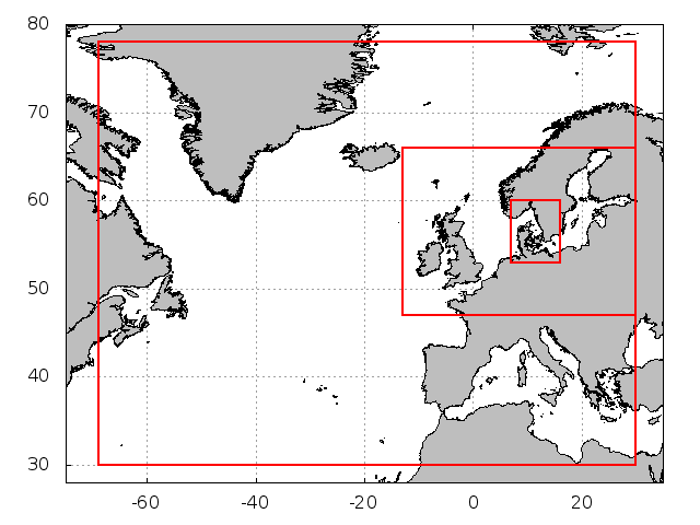
DMI-WAM has three geographical domains at present:
North Atlantic,
North Sea / Baltic Sea, and Transition Area (Danish Waters) (see figure and table below).
A Red Sea set-up was terminated March 2014
A North West Pacific / Yellow Sea set-up was terminated July 2014
A Mediterranean set-up was terminated December 2016
|
| model |
n.atlantic |
n.sea-baltic |
transition area |
| space step |
1/4°
(ca. 25 km) |
1/20° lat
1/12° lon
(ca. 5 km) |
1/100° lat
1/60° lon
(ca. 1 km) |
| advection time step |
2 min |
30 sec |
10 sec |
| source term time step |
6 min |
| number of directions |
36 |
| number of frequencies |
35 |
| sea points |
47457 |
92314 |
139639 |
| long |
69W-30E |
13W-30E |
7E-16E |
| lat |
30N-78N |
47N-66N |
53N-60N |
| forcing |
ECMWF GLM |
Harmonie NEA
ECMWF GLM |
Harmonie NEW
ECMWF GLM |
| boundary |
JONSWAP |
nested |
nested |
| depth map |
Rtopo |
Rtopo/IOW/KDI |
Rtopo/KDI/GEO |
|
Revisions.
Depth maps
The basic depth map is the
Rtopo 30" by 30" global bathymetry. This is used in the North Atlantic. In high-resolution domains, rtopo is combined with local depth information from various sources.
Model boundaries
The North Atlantic model uses the
JONSWAP wind-sea spectrum
along open model boundaries.
The fine grid North Sea - Baltic model is nested into the North Atlantic model,
and uses time/space interpolated boundary wave spectra calculated by that model.
The Transition Area model is further nested into the
North Sea - Baltic model.
Energy spectrum
The wave energy is discretized into 36 directions
(10
° resolution),
and 35 frequencies ranging from 0.04177 Hz to 1.06417 Hz in 10% steps.
That corresponds to wave periods of 0.94-23.94 seconds, and wave lenghts of 1.37-895 meters (in deep water).
To avoid excessive shadow effects from islands,
the spectral directions are shifted away from the major compass directions.
To speed up wave growth from calm sea, the spectral energy has a lower limit corresponding to
a wave height of 11.3 cm. This parameterises
capillary waves.
Depth-induced wave breaking (method taken from the
SWAN wave model) is used in the North Sea - Baltic Sea and Transition Area models only. In the North Atlantic model, the depth maps are not detailed enough for activation of this effect.
Initialisation
DMI-WAM is coldstarted once and for all using fully developed sea.
Subsequent model runs are initialised using the sea state at analysis time,
calculated by the previous run as a 6 hour forecast.
Wind
The 10 meter wind forcing is provided by DMI's limited area nwp model
Harmonie, version NEA (2˝ km resolution).
Harmonie provides 2˝ days of forcing.
Forecasts beyond that are based on the ECMWF global weather forecast (9 km resolution).
Harmonie wind is available every hour, ECMWF data every hour until 2˝ day forecast range, 3-hourly beyond.
To diminish coastal effects, DMI-WAM uses a special Harmonie 'water-wind',
in which the surface roughness everywhere is assumed to be that of water.
This enhances the wind speed in the coastal zone, most important in semi-enclosed areas (bays, fjords, ..).
Sea Ice
The ice concentration is daily OSISAF (radar-based) maps in ~10 km resolution. The maps are preprocessed to weather model grids,
and then further onto wave model grid.
A grid point is considered ice-covered when the concentration exceeds 0.3. The ice cover is kept constant thru each model run.
Documentation
DMI technical report
DMI-WAM Version 4 (pdf) of May 2003.
Verification
DMI-WAM is verified on a daily and 6-monthly routine basis versus buoy data, and on a 6-monthly routine basis versus satellite altimetry data. DMI-WAM further takes part in a comparative validation exercise, that is updated automatically every month at ECMWF and published on the LC-WFV (WMO / ECMWF : Leading Center for Wave Forecast Verification) project home page.
DMI verifikation
LC-WFV project description
Archives
DMI-WAM was first put to use medio 1999. Output has been archived since April 2000. Some model domains were
not implemented until later years.
For some model domains, an 11 year re-run has been carried out using the most recent version of DMI-WAM.
This archive contains the years 2003-2013.
Statistics
A frequency distribution analysis of wave height has been carried out, based on 1-7 years of DMI-WAM output. Please refer to the
wave statistics page.
....................