Synthetic Aperture Radar (SAR) data for sea ice mapping
The prime source of information for operational sea ice services
including the North American, the Finnish, the Norwegian and the
Greenlandic ice service is satellite SAR data. These services represent
the largest operational users of SAR data world wide. Completely
automated mapping is not yet feasible but the manual interpretation is
aided using automated classification and feature enhancement techniques.
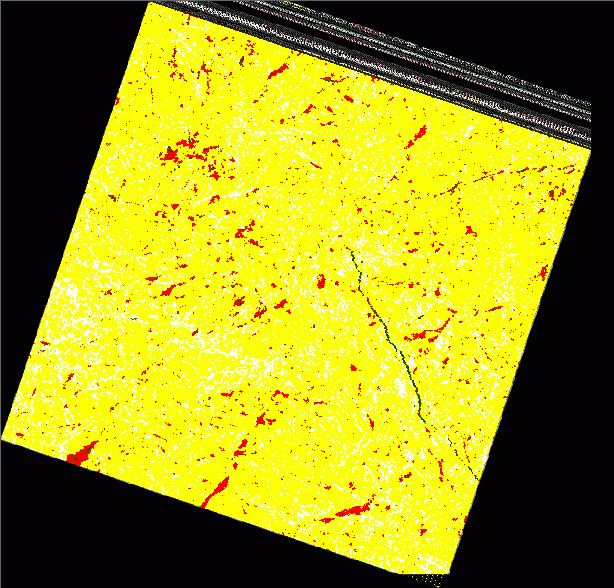
The figure shows a Radarsat standard mode (100x100km) image from the
Lincoln Sea May 15. 2004, classified into different ice types using a
semi-automatic fuzzy-logic algorithm.
Yellow - multiyear ice; White - ridges; Red - first-year ice; Green - leads (new-ice)
Read more (pdf):
Gill, R. S., R. T. Tonboe. Classification of GreenIce SAR data using fuzzy screening method. In: Wadhams & Amanatidis (Eds.) Arctic Sea Ice Thickness: past,
present and future. Climate change and natural hazards series 10, EUR
22416, 2007.
SAR image classification for validation
The use of thermal microwave data for mapping the sea ice extent and
area is perhaps the most successfull application of satellite remote
sensing for sea ice monitoring. Today time series covering the arctic
regions daily from the early 1970s, are most significant for estimating
inter-annual and decadal trends in this important climate parameter.
The reduction over the past decades in the multiyear ice extent is an
indication of an ongoing climate change process that affects the ice
thickness as well. Even small changes in the sea ice concentration have
a significant impact on energy fluxes between the ocean and the
atmosphere, i.e. a change from 100% to 99% may double the fluxes. Once
sea ice cover the ocean surface, the impact of ice thickness on
heatflux is relatively small. From a climate change perspective, the
key question is how fast the total volume of sea ice is changing. This
requires reliable estimates of ice concentration for the derivation of
the sea ice area. Therefore, ice concentration is an important ice
cover parameter and must be estimated accurately. The Mean accuracy of
some of the more common algorithms, used to compute ice concentration
from radiometer data are reported to be 1-6 % in winter. These
uncertainties are in general caused by atmospheric opacity, wind
roughening of open water areas, sensor noise and anomalous ice surface
emissivity.
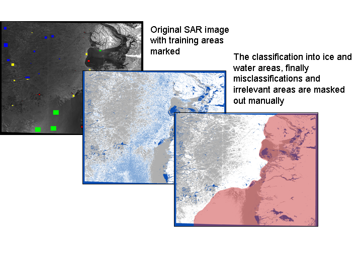
The high resolution SAR data can be used to compare with the radiometer ice concentrations estimates.
The figure shows the neural network classification of a SAR image from Baffin Bay.
Read more (pdf):
S. Andersen, R. T. Tonboe, L. Kaleschke. Satellite thermal microwave sea ice concentration algorithm comparison.
In: Wadhams & Amanatidis (Eds.) Arctic Sea Ice Thickness: past,
present and future. Climate change and natural hazards series 10, EUR
22416, 2007.