|
|
Boundary current surveys and hydrography
Across Fram Strait oceanographic exchanges have been monitored during the last decade.
During the IPY the EU project DAMOCLES and a number of national and International campaigns
are carried out with the goal of monitoring other parts of the Arctic Ocean. On the western side
of the Lomonosov Ridge in the Canadian sector, the on-going Switchyard initiative monitor freshwater
circulation and its variability between Alert, Ellesmere Island, and the North Pole by a repeat
hydrographic programme.
The oceanographic program is coordinated with the Switchyard initiative and aims at documenting
the characteristics of the pycnocline and upper ocean circulation in the region complementing
on-going international monitoring of the freshwater routes and export from the Arctic Ocean to
the North Atlantic. Large and possibly increasing discharges of freshwater into the Arctic Ocean
mainly from Canadian and Russian rivers (Peterson et al., 2002) are supplemented by in-flow from
Bering Strait, (Peterson et al., 2006) and by an atmospheric moisture influx.
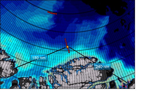 Surveys are planned along two sections (Figure 1): Section I, a near-meridional cross-section of
the slope of the Greenland shelf at the base of Morris Jesup Rise, and Section II, a near-zonal
section in the Transpolar Current perpendicular to the Lomonosov Ridge into the Amundsen Basin.
The programme complements the Switchyard studies with surveys of water masses and boundary current
structure.
Surveys are planned along two sections (Figure 1): Section I, a near-meridional cross-section of
the slope of the Greenland shelf at the base of Morris Jesup Rise, and Section II, a near-zonal
section in the Transpolar Current perpendicular to the Lomonosov Ridge into the Amundsen Basin.
The programme complements the Switchyard studies with surveys of water masses and boundary current
structure.
Thus, Section I is positioned between the two exits of Arctic freshwater - upstream of Fram Strait
and downstream of Nares Strait. Ideally Section I contains the flux of freshwater not lost to the
Nares Strait trough-flow and added to the contribution from the Transpolar Current. This water will
eventually reach Fram Strait where it exits or is partly re-circulated (Fahrbach, 2001). Section II
is included to give an independent estimate of the boundary current system by the Transpolar Current.
The ice camp forms the base of operation and stations will be reached using helicopter. In total, 14
hydrographic stations using a CTD/O2 system reaching down to 1000 meter are planned, 8 to complete
Section I and 6 on Section II. XCP probes will be used to collect information on the current shear
and to estimate the volume of transports in the boundary-current system.
Formation of the Polar Halocline waters by shelf processes and ice edge convection are remote to
the study area. However, in light of the recent reports of reduced coverage and thinning of the
Arctic ice and changes in the Arctic halocline structure (Steele and Boyd 1998), an understanding
of the spreading of halocline water and Atlantic derived waters of the lower halocline is fundamental
for predicting how the Arctic Ocean may respond to climate change. The hydrographic programme
including oxygen will allow us to examine if intermediate waters in the area are locally formed
and injected into the pycnocline or advected from outside (Faulkner et al. 2005). Moreover,
hydrographic data in this hitherto unexplored region will be an important contribution to the
international task of documenting the present state of the polar Halocline of the Arctic Ocean.
|
