|
|
Paleoclimate
This integrated part of the project aims at mapping past ice conditions in the Arctic Ocean north
of Greenland and reconstruct past climate variability by multi proxy analyses of sediment cores
collected during the drift of the ice camp.
Results from sediment cores retrieved during the 2004 GreenIce campaign over the southernmost part
of Lomonosov Ridge showed that this area was almost ice-free on at least two occasions during the
last 130.000 years including a short interval during the last Glacial period, indicating a strong
Atlantic Water advection and a reduced area of sea ice (Nørgaard-Pedersen et. al. 2007a, b).
This finding challenge the common view that the area north of Greenland would be the sector of the
Arctic Ocean where sea ice would remain most stable during a warming event. This finding therefore
has to be confirmed for a larger area of the Arctic Ocean, since most climate models predict only
limited reduction of the ice cover over the area north of Greenland during a warming world.
 It is also essential to clarify where paleo-ice margins were located and how different parts of the
Arctic Ocean reacted in the past to an atmospheric and oceanic warming in order to understand the
present and future conditions. To do so, a higher resolution and spatially better covering time-series
of past sea-ice proxies and surface and bottom water characteristics are needed in this highly important
area north of Greenland. Using a multitude of proxy series (Pb210, AMS C14, Thorium 230 Excess and
luminescence), links will be established between information on changes in the open ocean circulation,
changes in coastal waters and terrestrial records on land. The results form a basis for assessing past
climate changes and the response to current climate variability and identify its role in the Arctic
Ocean as a whole. Furthermore, there are indications that after the last interglacial glacial inception,
a large floating ice shelf built-up in this region in the middle Weichselian. We will investigate
this possibility of past extreme glaciations in the region as disintegration of such an ice shelf
may have led to fundamental oceanographic changes with far-reaching implications to the northwest
Atlantic thermohaline circulation. It is also essential to clarify where paleo-ice margins were located and how different parts of the
Arctic Ocean reacted in the past to an atmospheric and oceanic warming in order to understand the
present and future conditions. To do so, a higher resolution and spatially better covering time-series
of past sea-ice proxies and surface and bottom water characteristics are needed in this highly important
area north of Greenland. Using a multitude of proxy series (Pb210, AMS C14, Thorium 230 Excess and
luminescence), links will be established between information on changes in the open ocean circulation,
changes in coastal waters and terrestrial records on land. The results form a basis for assessing past
climate changes and the response to current climate variability and identify its role in the Arctic
Ocean as a whole. Furthermore, there are indications that after the last interglacial glacial inception,
a large floating ice shelf built-up in this region in the middle Weichselian. We will investigate
this possibility of past extreme glaciations in the region as disintegration of such an ice shelf
may have led to fundamental oceanographic changes with far-reaching implications to the northwest
Atlantic thermohaline circulation.
In order to provide a coherent picture of past ice conditions north of Greenland cores will therefore
be retrieved from high sedimentation rate basins in different parts of the survey area. This will
facilitate a detailed study of variations in the past ice cover and establish a picture of the
general circulation pattern of the Arctic Ocean covering a time span of some hundred thousand years
i.e. one or more glacial-interglacial cycles - and generate data which are important to validate
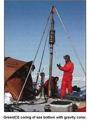
current climate models. Practical coring operation will draw on the experiences gained from the
successful coring carried out under the GreenIce ice camp activity in 2004 where cores were
retrieved with the light-weight equipment developed by GEUS (Mikkelsen et. al, 2006). Continuous
seismic profiling will be undertaken during the drift of the planned IPY ice camp in the same
manner as it was successfully done in 2004 (Kristoffersen & Mikkelsen, 2006) in order to find
suitable sediment basis for coring.
|
