|
|
Snow and ice remote sensing
 Sea-ice studies and climate
Large scale as well as detailed ice conditions and ice dynamics will be monitored from a multitude
of satellite and airborne laser and radar measurements. Simultaneous measurements of microwave
signatures by satellite and airborne sensors and in situ snow/ice properties will be carried out.
This work will provide valuable information for validation of recent theoretical advances in
modelling of microwave signatures of ice and snow (Tonboe et al, 2006a and 2006b). The radiometer
data will also strengthen the re-analysis of the microwave satellite record - an ongoing joint
European - American project. The observations of ice dynamics from satellite will be compared to
earlier years ice conditions with the view to understand the navigability of the region for ice
breakers, especially in view of the very difficult conditions met in 2007 during the LOMROG cruise. Sea-ice studies and climate
Large scale as well as detailed ice conditions and ice dynamics will be monitored from a multitude
of satellite and airborne laser and radar measurements. Simultaneous measurements of microwave
signatures by satellite and airborne sensors and in situ snow/ice properties will be carried out.
This work will provide valuable information for validation of recent theoretical advances in
modelling of microwave signatures of ice and snow (Tonboe et al, 2006a and 2006b). The radiometer
data will also strengthen the re-analysis of the microwave satellite record - an ongoing joint
European - American project. The observations of ice dynamics from satellite will be compared to
earlier years ice conditions with the view to understand the navigability of the region for ice
breakers, especially in view of the very difficult conditions met in 2007 during the LOMROG cruise.
 Ice drift tracking will be made using daily satellite SAR data. ENVISAT ASAR data are available
to the project from ESA through accepted AO projects. Shorter term drift e.g. inertial motion and
differential motion due to internal ice stress will be obtained by deploying a network of GPS
equipped buoys in collaboration with SAMS. Satellite data will be analysed in a four-month
period around the ice camp operation and made available at short delay. The ice-motion data
will also be used for validation of ice drift models for the area in collaboration with FIMR.
Ice drift tracking will be made using daily satellite SAR data. ENVISAT ASAR data are available
to the project from ESA through accepted AO projects. Shorter term drift e.g. inertial motion and
differential motion due to internal ice stress will be obtained by deploying a network of GPS
equipped buoys in collaboration with SAMS. Satellite data will be analysed in a four-month
period around the ice camp operation and made available at short delay. The ice-motion data
will also be used for validation of ice drift models for the area in collaboration with FIMR.
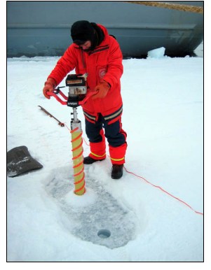
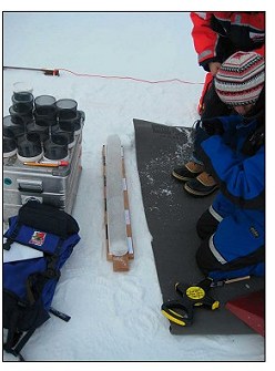
In addition, the proposed camp will provide opportunities for both airborne and in-situ ice
thickness data collection. Airborne activities will contribute to laser flights in long transects
across the Arctic Ocean The measurements by the DNSC airborne laser scanner system provide detailed
information of sea-ice freeboard heights based on precise GPS swath laser scanning and a precise geoid model
(Hvidegaard & Forsberg, 2002), (Forsberg & Skourup, 2005). 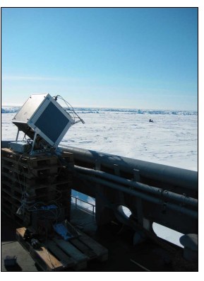 The measurements allow estimation of ice
thickness based on estimates of snow depth information and assumed densities of ice and snow.
Validation of the airborne measurements is therefore essential, both in time and space. Planned
local helicopter measurements (by AWI) using an EM-sensor, as well as in-situ snow and ice data
(FIMR, UC/SAMS, DNSC) will provide the necessary ground truth for the laser data and for
validation of similar satellite measurements (ICESat and Cryosat-2).
The laser flight programme
as already been funded (EU-DAMOCLES project). As part of the Alert-based ESA CryoVex-08 experiment
(an international Cryosat pre-launch campaign) additional flights will be made over the ice camp
region by DNSC with simultaneous laser and radar measurements, allowing for the first time simultaneous
airborne and in-situ measurement of snow depth from a laser/radar combination.
The measurements allow estimation of ice
thickness based on estimates of snow depth information and assumed densities of ice and snow.
Validation of the airborne measurements is therefore essential, both in time and space. Planned
local helicopter measurements (by AWI) using an EM-sensor, as well as in-situ snow and ice data
(FIMR, UC/SAMS, DNSC) will provide the necessary ground truth for the laser data and for
validation of similar satellite measurements (ICESat and Cryosat-2).
The laser flight programme
as already been funded (EU-DAMOCLES project). As part of the Alert-based ESA CryoVex-08 experiment
(an international Cryosat pre-launch campaign) additional flights will be made over the ice camp
region by DNSC with simultaneous laser and radar measurements, allowing for the first time simultaneous
airborne and in-situ measurement of snow depth from a laser/radar combination.
An automatic weather/climate station will be installed at the camp based on the 2004-experiences by
GEUS in using a low cost climate station to provide air pressure, temperature, wind and radiation balance data.
|
