|
|
The Frozen Sea
Since the 1970s the extent of sea ice has been measured from satellites. From these measurements
we know that the sea ice extent today is significantly smaller than 30 years ago. During
the past 10 years the melting of sea ice has accelerated, and especially during the ice extent minimum in
September large changes are observed. The sea ice in the northern hemisphere have never been
thinner and more vulnerable.
Sea ice is an important element in the understanding of the global climate system. The changes
in sea ice extent is closely monitored and analysed by various climate centers around the world.
The Danish Meteorological Institute monitors
weather, sea and ice in the Arctic for several reasons. Partly to follow the climatological
development, partly to produce physical data products for numerical weather and sea models,
and partly to support ships with the latest ice observations.
In the left column on this web page,
The Arctic
Today, You can find static and dynamically updated information about the state of the Arctic, and to the
right you find a list of our latest news and articles.
|
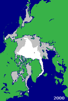


The above animation shows the ice extent in the middle of February for the period 2000-2009.
Grey areas indicate the extent of the relative thin winter ice, and white area indicate
the extent of the thicker multi year ice. The animation is based on QuikSCAT satellite data.
|
